Top ultra-local Grønolslie walks
Here's three suggestions in case you have an extra hour or two left before or after other activity, or want a short trip one day with lesser weather.
1. Grønolshøvda / Blåhøvda / Nordre Høvda
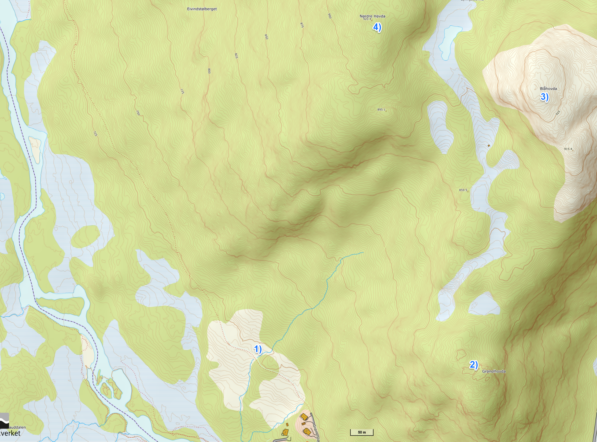
From the cabin (left in the picture), 30m to the tiny creek, 20m up along the creek to a wider track that you follow for about 300m. At the map point 1) follow the nicely marked track to Raudhorn 2). From here you might of course just enjoy the view and turn around, or proceed to either the higher Blåhøvda 3) or the almost as high Nordre Høvda 4). Blåhøvda has just as nice view, and you go back the same way.
My favorite is Nordre Høvda, with more wildlife. Tip: Approach silently to the top and over! Not many people go here, not marked.
From here you can of course turn around and go bask the same way, but going west or south-west towards the river is lovely. Challenge yourself a little in finding good lines in downhill, not so steep or hard.
You are guaranteed to find the wider track a while before the river, follow left/south back to the cabin.
2. Up along the Gipa river, to Raudhorn
From the living room view in Grønolslie Raudhorn (Red horn) rises in center with clearly visible red iron/rust on the side of its cap when the light is right.
Cross the river Raudøla at the road bridge 800m south of Grønolslie. You can use the cross country clearing from Grønolslie. From there, walk some 500m and take the road to the right through a group of cabins. Go on 700m. Then left at the fork, another 200m and you see the track up to the right.
You get a great view when you reach the plateau, from here you can see signs and marks and follow the track up to Raudhorn.
Notice that as you approach the peak of Raudhorn things might look a bit challenging, but go closer and you see that it is both easy and safe to "climb" this.
After checking the top view and maybe having identified some mountains ahead, proceed and circle back in between Gipa tjernene/ponds.
The more or less marked track will take you up to the ridge again, and you might decide it's fine to call it a day, go straight and then down where you came up.
But there's a bonus option if you don't go up here and instead continue along the east banks of the remaining ponds, to the final outlet where the little river starts flowing. If you follow this river 500m - and be very careful here - you will reach a huge stone plate that is funneling the river into a straight 60m drop. There are bigger water falls around, but this one is still amazing with the round valley shape, like a crater.
Don't go here at all if you are very tired - observe and be sure to make your steps right. Do not try to travers from the waterfall-top at same height back to the track, although there's oddly enough vegetation here it is just too steep and totally unsafe.
Instead, go back at least 50m, then acend straight up (no track needed) and you are back to the original track in 300m or so.

3. Along the fisherman's track
This is an opportunity to sneak upon wildlife (wetland birds and elk tend to like it here!), while you walk along a very beautiful river. If you prefer walking along roads, this is not it. You have to bend and lift your feet a bit.
From the cabin, instead of starting the track up to Grønolhøvda, follow the wider track further north, all the way to it ends in a semi-wet plain. (mark in map below)
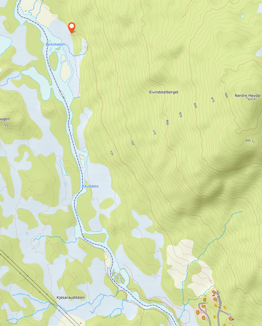
From here, go all the way down to the river. Head south, and in case very wet times you may have to go 20m "inland", but return all the way down to the river in 30-40m. From here follow alongside the river all the way back to the cabin, of better, do this exercise all the way down to the lake Øyangen.
This trip only works if you actually and literally walk alongside the river. It is easy to walk away from the riverside at places where open places are seen away from the river. But trust me, all those I know of that did not follow the river strictly, were disappointed and a often quite stuck in dense vegetation.
If it looks like you can't pass along the riverside, trust me, just press yourself closer and you are back at the fisherman's track!
Going further?
UT.no is always a safe bet, for all hikers. A lot of good content for most of Norway.
I like peakbook.org a lot for even more options (great content for Jotunheimen etc). Often more original tracks, sometimes more demanding - and rewarding. But know your limitations.
Daytrips with short drive from the cabin
Here's some recommendations for starters in the area.
Bitihorn
The iconic mountain of Beitostølen. For solitude, avoid high season! But at some point you might want to do this trip as it is very accessible, easy and takes less than half a day. Parking and start from east at Båtskaret with "The German Track" for steeper and faster ascent.
Or from the parking called "The Sami camp" for a less steep and very friendly ascent from the north.
Rasletinden
Very accessible from the FV51 mountain pass at Valdresflye, a must for anyone collecting relatively easy "2000-peaks".
If you have quite a bit extra capacity and have the calm for moving along very steep ridges, then you will find that Mugna, Austra Kalvehøgda and the rest of the long ridge Kalvehøgda is not far from Rasletinden. Relatively easy walk to the west, but no marked path. Alteady at Mugna you see the stunning crater of Leirungsbreen, way down..
Mugnetind
From Beitostølen, this is seen as the highest peak in western direction. Great views in all directions from the top. Beautiful and varied route. The path is good and safe. The trip is often marked "challenging", but that is in my opinion because of length and ascent only.
Either walk from the cabin, see trip Raudhorn above, but skip the peak and instead go straight to the usual route start at Mugnestølen.
Or drive (or bicycle) to Mugnestølen where you park and start. The last part is a private toll road, easy payment on web later on.
Skaget
Relatively easy, accessible, and does not take all day. A nice walk, nice views all around, not crowded at all. A short drive from the cabin.
Knutshøe
Beware, eagles nesting! Please don't go before last half of July.
Not so high, but the mountain has an delicious shape, and is in a posision that gives you amazing views. One of my favourites, if you can't or won't use a full day.
In the middle between easy and hard. At the very beginning of the ascent there's some bolted chains for your aid for a 5 meter relatively easy climb. It naturally serves as a warning for anyone not reasonably fit, with some experience and good shoes etc. Because of the eagles, and a period with too much hikers in a very accessible area, tracks published on websites and physical route markers were removed. You are allowed here by law and I think everyone should feel ethically allowed to take the route every twenty years..
Parking along and outside FV51, as close as you get to the south end of the Knutshøe ridge. There's a clearly visible track all the way to the ridge. Along the ridge, pay attention to stay approximately in the center. There have been accidents with inexperienced hikers taking crevices for a path.
When going down on the other end, the path turns left/west and you have a nice walk along the mountain foot and the beautiful lake just on the other side, and you are back.
Tjønnholstinden
Solitude almost guaranteed! Hikers say, and I totally agree, there's no other place that has this striking contrast between a nice but quite ordinary mountain ascent, and the revelation that meets you the second you step forward at the top and see the massives and the glaciers down and beyond. You are in for a very pleasant surprise if you can make it. A bit long and hard, but not crazy hard.
Start as with Knutshøe, but just before the ascent you go left/southwest and cross the river Leirungsåe at the first bridge upstream. Soon you leave the path and go uphill in unmarked terrain. You can have aid from downloaded GPS-tracks at Peakbook. (you need to do a free register)
